

BRIC5 Survey Tool
5th Generation
A high precision ruggedized survey tool designed for mapping in the harshest subterranean conditions. Accurately captures 3D vectors of azimuth, inclination, and distance. Uses Bluetooth to send measurements to mapping applications. Includes redundant sensors and advanced error detection for complete confidence in survey data.
Update Dec 19, 2025: BRIC5 Production Ending
After almost 5 years and 500 units built, I’ve had to make the difficult decision to end production of the BRIC5. I’m expecting a new baby in January and I won’t be able to support this project along with family and a full-time job. I still have a good supply of spare parts and will continue supporting the BRIC5 with repairs and maintenance; please email me at bricsurvey@gmail.com. Perhaps in a few years with more free-time I will come back with a new and improved BRIC6!
I wanted to thank some people who have helped me on this project over the years; this would not have been possible without you!
John Fioroni - Sales and shipping through the Cave Exploration Society and early field testing of units.
Rich Smith for integration into the Sexy Topo app
Marco Corvi for integration into Topo Droid
Paulina Piechowiak for integration into Qave
Aleksandar Stoev for integration into CaveSurvey
Lynn Brucker for precision calibration validation and field testing
L. Yusnaviel García-Padrón for Spanish translations
Domi Ros for translations in French and Spanish
Anri Hazday for Bulgarian translations
Caleb Crubaugh and Aaron Bird for reviews and instructional videos regarding calibration.
Mike Green for sales and shipping through Inner Mountain Outfitters
And most importantly I’d like to thank everyone that has purchased a BRIC! I hope they last for many more years to come.
- Kris Fausnight
Latest firmware:
BRIC4 Version 6.8 & BRIC5 Version 7.6 Released March 5, 2025
Fixed bug in quick-Azimuth calibration which could cause calibration to fail and revert to default values.
Added feature to allow normal operation with a failed sensor.
Eliminated laser time-out during calibration and loop test.
Improvements to loop test; error message and ability to undo a leg
BRIC4 Version 6.9 & BRIC5 Version 7.7 Released April 24, 2025
Reduced compass “Failed Sensor” threshold to account for low magnetic fields in South America. Was causing false failures.
Features
High Accuracy
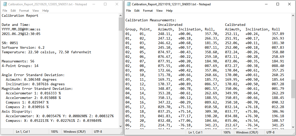
Azimuth: <0.2° Precision, <0.4° Accuracy
Inclination: <0.1° Precision, <0.2° Accuracy
Distance: 1mm Precision, 3 mm Accuracy
Detailed calibration report generated for each calibration. Saved to device and viewable through main screen.
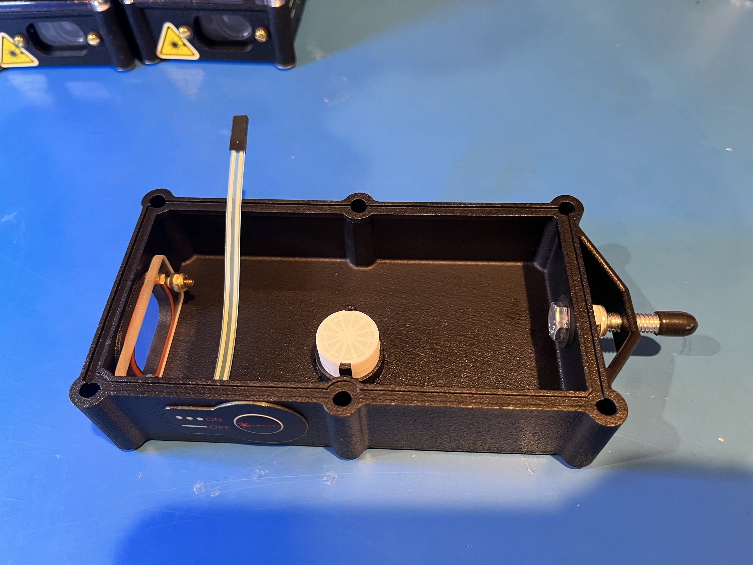
Redundant sensors and advanced error detection ensure complete confidence in data.
2x PNI RM3100 Magneto-Inductive Magnetometers
2x Murata SCA3300 Industrial MEMS Accelerometers

Rugged Construction
Waterproof (IP-67) and floats
Shockproof construction
Integrated sensor assembly unit on rubber isolators
3D printed HP MJF Nylon Case and Polycarbonate top.
Membrane-style switches impervious to mud and water.
Sealed USB-C Port
Pre-installed Screen Protector
Internal desiccant to prevent fogging/icing
Weight & Dimensions:
300 grams (0.66 lbs)
17.5 x 8.1 x 3.8 cm (6.9 x 3.2 x 1.5 inches)

Bluetooth Data Transfer and Control
Bluetooth Low Energy (BLE) 4.2
Measurement data transfer to survey applications for digital surveying
Remote control of instrument via bluetooth
“Scan” mode performs 1-10Hz continuous measurements for pseudo-lidar
Compatible with most survey applications.
TopoDroid
CaveSurvey
SexyTopo
Qave

Easy To Use and Calibrate
Large LCD screen and intuitive interface
One large external button for turning on/off and taking measurements.
4-button keypad for options, calibration, etc.
Simple calibration routines, no external equipment or software required.
15 minutes for full calibration
3 minutes for quick-Azimuth calibration
All data logged on device in .csv files and viewable on the main screen.
USB-C port for data-transfer and charging.
1800 mAH rechargeable lithium battery
Estimated 100 hours of use


Review of the BRIC5 by Caleb Crubaugh
“BRIC5 Survey and Calibration” on youtube.com
Review by Aaron Bird at the 2021 NSS Convention
“Evaluation of the BRIC4 cave-surveying device”
